
Recherche dans les données descriptives
942 items
-
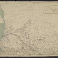
Carte générale de l'Afrique occidentale française, 1906-1908 flle n°1, Sénégal, Mauritanie, partie occidentale du Haut-Sénégal et Niger / Service géographique du gouvernement général de l'AOF
Tableau d'assemblage montre 4 flles numérotées de 1 à 4. carton : "Détails de la baie du lévrier" ; "Limite séparative des zones d'influence respective de l'Algérie et de l'Afrique occidentale française". Coordonnées géographiques converties du méridien de Paris au méridien de Greenwich -
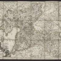
Der Pernausche Kreis = = Le cercle de Pernau : / gezeichnet von L.A. Graf Mellin ; gestochen von Carl Jættnig in Berlin 1797
[1:300 000 env.] (E 2338' - E 2626' / N 5846' - N 5747'). En bas à gauche : illustrations décoratives ; 3 échelles graphiques. Egalement dans : Atlas von Liefland, oder von den beyden Gouvernementern u. Herzogthumern Lief- und Ehstland und der Provinz Oesel ... = Atlas de la Livonie, ou des deux Gouvernemens et Dúchés de Livonie et d'Esthonie avec la province d'Oesel ... - Riga [etc.] : J.F. Hartknoch, 1798. Coordonnées géographiques converties du méridien de l'Ile de Fer au méridien de Greenwich -
[Mapas de la Rejión Andina, escala de 1:250 000] [1], / [Cartografía levantada por] Vidal, Heuisler,Steffen,...[et al.] ; Comision chileana de limites
"Completado con los planos de la Oficina Hidrográfica, los de la Comision Arjentina de Limites, los datos de hijuelacion del plano de la Gobernacion del Chubut de Wilkinson i Lefrançois (1903) i otros.". Légende en espagnol. Titre et numéro de feuille d'après le tableau d'assemblage de cette série. Carte en 6 feuilles. Relief représenté par estompage et par des points cotés. Biblioteca Nacional Digital de Chile -
[Mapas de la Rejión Andina, escala de 1:250 000] [4], / [Cartografía levantada por] Michell 1898-1902, Moreno 1898-99 ; Comision chileana de limites
"Completado con los planos de la Comision Arjentina de Limites i el plano del territorio de Santa Cruz de la Division de Tierras i Colonias (1904).". Légende en espagnol. Titre et numéro de feuille d'après le tableau d'assemblage de cette série. Carte en 6 feuilles. Relief représenté par estompage et par des points cotés. Biblioteca Nacional Digital de Chile -
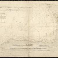
Sondes d'atterrage de la côte Sud-Ouest de France et de la côte Nord d'Espagne : faites en 1828 et 1829
3 vues : Vue de l'entrée de La Corogne ; Vue du cap Ortegal ; Vue des entrées de Saint Sébastien et du port du Passage -
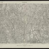
[Spezialkarte der Osterreichisch-Ungarischen Monarchie, Maßstab 1:75 000]. Zone 22, Col. VIII, Strassoldo
Titre porté sur le tableau d'assemblage. Carte de base 1902, dressée pour l'interieur ("Inland") d'après les levés 1896 u. 1897 et la légende établie en 1894. Porte: "Schrift der Wohnorte analog der Generalkarte". Relief représenté par des hachures et points cotés. Les coordonnées de la flle. sont au méridien de l'île de Fer. Les coordonnées E/N indiquées pour la localité sont au méridien de Greenwich -
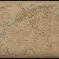
Carte du Sahara et du Nord-Ouest de l'Afrique, de la Mediterranée au Sénégal et au lac Tchad / Dressée par P.Vuillot, Membre de la Société de Géographie de Paris...
Lieux où ont été massacrés les pères Blancs en 1875 et en 1880. Index des termes Arabes et Berbères. Double de la carte se trouvant à la fin de P.Vuillot, l'exploration du Sahara, 1811. 4 Lk 8. Dessiné et gravé par R.Hausermann. Supplément au journal Les Missions catholiques, 1895. Coordonnées géographiques converties du méridien de Paris au méridien de Greenwich -
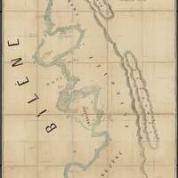
Esboço hydrographico do Rio Limpôpo : entre a Ilha dos Patos e o Váo do Gongunhana, abragendo o rio Changâne até ao Monte Chibuto / Alvaro Andréa
[ca. 1:18 650] (E 3333' - E 3341' / S 2440' - S 2455'). Carte découpée et collée sur tissu. "Feito pelo 1o. tenente da Armada Alvaro Andréa commandante da Lancha Ca. 'Capêllo' durante as operações de campanha de setembro a dezembro de 1895.". Relief montré par des hachures. Bathymétrie en pieds.. échelle et coordonnées géographiques issus de la notice ocm54627596 -
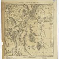
District of New Mexico / Lt. C.C. Morrison, 6th Cav. U.S.A., acting eng.r officer ; drawn by Anton Karl
"Headquarters Dept. of the Mo., Office of the Chief Engineer. Fort Leavenworth, Kas. Aug. 1845. Official copy William J. Volkurar 1st Level 5th Cav. in charge of office in abscence of Chief eng. Drawn by Anton Karl ; copied by G.A. Lichtenberg, Sergt. Engr.". Indique les forts de l'U.S. Army. Comprend liste des autorités : "Land office plats ; Boundary line surveys North East and South ; Maxwell Land Grant Survey ; Route of Capt. Macomb in 1857 ; Route of Capt. Simpson in 1849 ; Scouts in New Mexico since June 1872 ; Map of New Mexico by Lt. Ruffner ; Reconaissances by Lt. C.C. Morrison." -
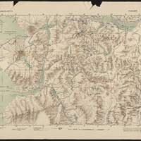
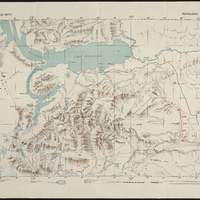
Block diagram showing terrain of the Trieste-Isonzo region
1:150 000. Bloc diagramme : "Représentation graphique, en perspective, à partir de photographies ou de cartes, d'un espace donné montrant par des coupes contiguës les rapports entre la structure géologique du sous-sol et la topographie". La carte porte en plus : "Marginal figures refer to the zones and columns of the General Staff map of Austria; Scale 1: 75 000 upon which this diagram is based. The corners of the sheets are indicated within the diagram by crosses placed at sea level position. Approximate scale in center of diagram 1:150 000 vertical exaggeration about 2 1/2 times. Elevation in feet". Relief indiqué par dessins, hachures et points cotés -
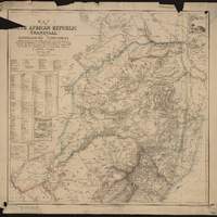
Map of the South African Republic (Transvaal) and the surrounding territories : compiled from ... the ... observations and exploring Routes of C. Mauch, C. Mohr, A. Hubner, T. Baines, S.V. Erskine, Capt. Elton, Col. Colley, Capt. Bawden, R.T. Hall, Dr. E. Cohen, etc. ... / by F. Jeppe, F.R.G.S. Pretoria, 1877
Cartons : "Plan of Pretoria" , View of the ruins", "Plan of Lourenço Marques (Del Bay)". En index : tableau des distances -
Côte ouest de France. De la pointe de la Coubre à la pte. de la Négade. Embouchure de la Gironde
[1:49 000 env.] (W 127' -- W 054' / N 4543'40'' -- N 4528'15''). Les sondes sont exprimées en mètres. Carte numéroté : "4868" et "6-22". Tableaux des hauteurs de marée. Première édition en 1894. Edition de mai 1896. Coordonnées géographiques converties du méridien de Paris au méridien de Greenwich. Echelle calculée par comparaison avec une carte d échelle connue -
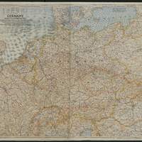
Germany and its approaches : with international boundaries as of September 1, 1939, the day Germany invaded Poland and, in red, boundaries as of January 1, 1938 before Germany seized Austria and Czechoslovakia / compiled and drawn in the Cartographic Section of the National Geographic Society for the National Geographic magazine / James M. Darley, chief cartographer ; Gilbert Grosvenor, editor
Carte de l'Allemagne et des pays voisins, montre les routes, les chemins de fer, canaux, tunnels, villes, régions, hydrographie et frontières d'états en 1938/1939 -
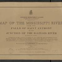
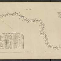
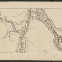
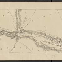
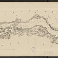
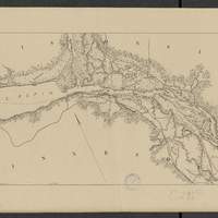
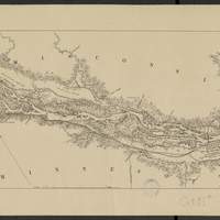
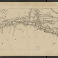
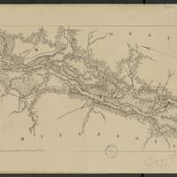
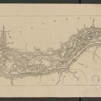
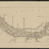
Map of the Mississippi River : from the Falls of Saint Anthony to the junction of the Illinois River in twenty-six sheets / drawn under the direction of Brevet Lieut. Col. F.U. Farquhar ; by F.S. Eastman
[1:63 360] (W 9316' - W 905' / N 45 - N 3850'). "Note : The position of the lights, as establlished in 1877 by the Light-House Board, are indicated on the map.". compiled from the maps prepared to accompany the reports of Bvt. Maj. Gen'l. G.K. Warren, U.S. Army Maj. Corps of Engineers, on bridging the Mississippi river between St. Paul and St. Louis ; and upon the improvement of navigation of the Mississippi River between the Falls of St. Anthony and the Rock Island Rapids, with additions from notes and surveys under the direction of Col. J.N. Macomb, Corps of Engineers. Comprends : 1 flle de titre ; 1 flle de tableau d'assemblage contenant un tableau des distances ; 26 flles de cartes numérotées de "sheet 1" à "sheet 26". Coordonnées géographiques d après Google Earth. Echelle d'après l'information : 1 inch to 1 mile -
Map of the Mississippi River : from the Falls of Saint Anthony to the junction of the Illinois River in twenty-six sheets / drawn under the direction of Brevet Lieut. Col. F.U. Farquhar ; by F.S. Eastman
[1:63 360] (W 9316' - W 905' / N 45 - N 3850'). "Note : The position of the lights, as establlished in 1877 by the Light-House Board, are indicated on the map.". compiled from the maps prepared to accompany the reports of Bvt. Maj. Gen'l. G.K. Warren, U.S. Army Maj. Corps of Engineers, on bridging the Mississippi river between St. Paul and St. Louis ; and upon the improvement of navigation of the Mississippi River between the Falls of St. Anthony and the Rock Island Rapids, with additions from notes and surveys under the direction of Col. J.N. Macomb, Corps of Engineers. Comprends : 1 flle de titre ; 1 flle de tableau d'assemblage contenant un tableau des distances ; 26 flles de cartes numérotées de "sheet 1" à "sheet 26". Coordonnées géographiques d après Google Earth. Echelle d'après l'information : 1 inch to 1 mile