
Recherche dans les données descriptives
1887 items
-
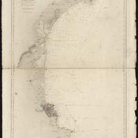
Carte des côtes méridionales de France. Partie comprise entre le cap de Creux et Cette
[1:153 000 env.] (E 243' -- E 350' / N 4325' -- N 4211'). Carte "No. 2358". Bathymétrie représentée par des points de sonde exprimés en mètres, relief représenté par des hachures. Révision en 1873. "Corrections secondaires en 1869, 1874,... III-86". Coordonnées de longitude converties du méridien de Paris au méridien de Greenwich. Echelle calculée par comparaison avec une carte d échelle connue -
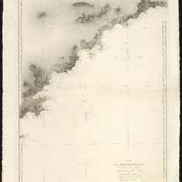
Carte des côtes méridionales de France. Partie comprise entre St. Tropez et la frontière
[1:153 000 env.] (E 630' -- E 737' / N 4355' -- N 4242'). Carte "No. 2682" et "9-28". Bathymétrie représentée par des points de sonde exprimés en mètres, relief représenté par des hachures. Révision en 1872. "Corrections essentielles en 1874, nov. 1880, janv. 1889". "Corrections secondaires en 1869, 1870, ... I-98". Coordonnées de longitude converties du méridien de Paris au méridien de Greenwich. Echelle calculée par comparaison avec une carte d échelle connue -
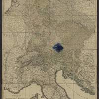
General-Karte von Deutschland, der batavischen und helvetischen Republik, ober und mittel Italien und dem östlichen Theil der französischen Republik... nach den Bestimmungen der neuesten Friedens-Schlüsse und Conventionen, ingleichen nach astronomischen Ortsbestimungen und den verzüglichsten Hülfsmitteln, auf Kosten der könig. Akad. der Wissenschaften in Berlin / entworfen von D.F. Sotzmann
[1:2 018 182 env.] (E 320' - E 1953' / N 5440' - N 4040'). Echelle calculée d'après 1 degré de latitude -
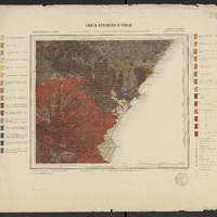
Carta geologica d'Italia F° 253, Castroreale (isola di Sicilia) / R. Comitato geologico d'Italia ; rilevato nel 1880-81, riveduto nel 1881, da E. Cortese
Les numéros des feuilles adjacentes sont indiquées sur les bords de la carte. Carte de base : Carta 1:100 000 dell'Istituto Geografico Militare (réduction des cartes 1:25 000 et 1: 50 000 enregistrées par les Ingénieurs des Mines, 1877-82). Légende en italien. Impression : "R. Stab Lit e Cartogr. C. Virano Roma 1885". Feuille d'accompagnement : "Carta Geologica d'Italia, Isola di Sicilia : Sezioni geologiche. Tav III (Relativa ai fogli 253, 254, 262 della Carta Geologica al 100 000) / Ing. E. Cortese, 1885". Les coordonnées de la flle. sont au méridien de Rome (1229' à l'est de Greenwich). Les coordonnées E/N indiquées sont au méridien de Greenwich. Relief représenté par des hachures et des points cotés -
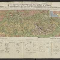
Mapa gospodarczo-osadnicza pasterstwa w Tatrach : i mapka etnograficzna z zasięgem wędrówek pasterskich i typów szałaśniczych = = Carte de la vie économique des bergers et leurs établissements dan les Tatra : et petite carte ethnographique avec l'extension des migrations pastorales et des types des chalets / opracowała Zofja Hołub-Pacewiczowa ; druk i oprac. kart. Wojsk. Instyt. Geograf. w Warszawie ; oprac. kart. por. Czarnota ; kreślił Wł. Oniszczyk
Légende structurée : I - terrains d'exploitation économique ; II A - types des chalets slovaques ; II B types des chalets de Jaworzyna -
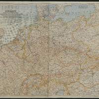
Germany and its approaches : with international boundaries as of September 1, 1939, the day Germany invaded Poland and, in red, boundaries as of January 1, 1938 before Germany seized Austria and Czechoslovakia / compiled and drawn in the Cartographic Section of the National Geographic Society for the National Geographic magazine / James M. Darley, chief cartographer ; Gilbert Grosvenor, editor
Carte de l'Allemagne et des pays voisins, montre les routes, les chemins de fer, canaux, tunnels, villes, régions, hydrographie et frontières d'états en 1938/1939 -
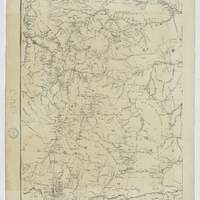
Map of the Yellowstone and Missouri Rivers : and their tributaries / explored by Capt. W. F. Raynolds, Topl. Engrs., and 1st Lieut. H. E. Maynadier, 10th Infy. Assistant, 1859-60 ; revised and enlarged by Major G. L. Gillespie, U.S. Engr's., Bvt. Lt. Col., U.S.A. Chief Engr. Military Division of the Missouri, 1876 ; published by authority of the Hon. the Secretary of War, Office of the Chief of Engineers, U.S. Army, 1876
En bas à gauche : "Western sheet. Map of Yellowstone and Missouri Rivers. From Capt. Raynolds exploration 1859-60, with additions by Major Gillespie. Published by authority of the Hon. the Secretary of War, Office of the Chief of Engineers, U.S. Army. 1877." -
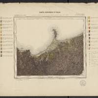
Carta geologica d'Italia F° 262, Monte Etna (isola di Sicilia) / R. Comitato geologico d'Italia ; rilevato nel 1881 da L. Mazzetti e E. Cortese ; riveduto nel 1882 da E. Cortese
Les numéros des feuilles adjacentes sont indiquées sur les bords de la carte. Carte de base : Carta 1:100 000 dell'Istituto Geografico Militare (réduction des cartes 1:25 000 et 1: 50 000 enregistrées par les Ingénieurs des Mines, 1877-82). Légende en italien. Impression : "R. Stab Lit e Cartogr. C. Virano Roma 1885". Feuille d'accompagnement : "Carta Geologica d'Italia, Isola di Sicilia : Sezioni geologiche. Tav III (Relativa ai fogli 253, 254, 262 della Carta Geologica al 100 000) / Ing. E. Cortese, 1885". Les coordonnées de la flle. sont au méridien de Rome (1229' à l'est de Greenwich). Les coordonnées E/N indiquées sont au méridien de Greenwich. Relief représenté par des hachures et des points cotés -
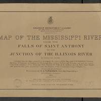
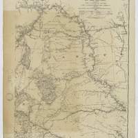
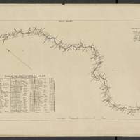
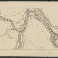
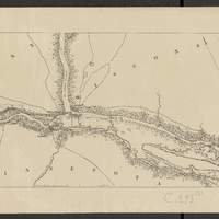
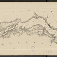
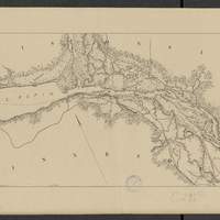
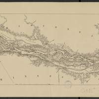
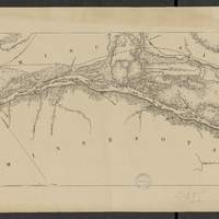
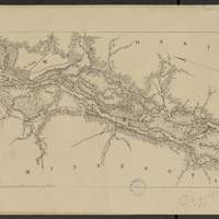
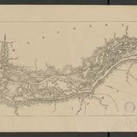
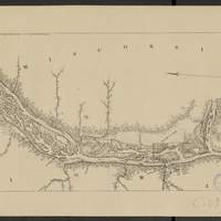
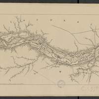
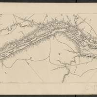
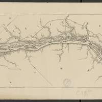
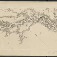
Map of the Mississippi River : from the Falls of Saint Anthony to the junction of the Illinois River in twenty-six sheets / drawn under the direction of Brevet Lieut. Col. F.U. Farquhar ; by F.S. Eastman
[1:63 360] (W 9316' - W 905' / N 45 - N 3850'). "Note : The position of the lights, as establlished in 1877 by the Light-House Board, are indicated on the map.". compiled from the maps prepared to accompany the reports of Bvt. Maj. Gen'l. G.K. Warren, U.S. Army Maj. Corps of Engineers, on bridging the Mississippi river between St. Paul and St. Louis ; and upon the improvement of navigation of the Mississippi River between the Falls of St. Anthony and the Rock Island Rapids, with additions from notes and surveys under the direction of Col. J.N. Macomb, Corps of Engineers. Comprends : 1 flle de titre ; 1 flle de tableau d'assemblage contenant un tableau des distances ; 26 flles de cartes numérotées de "sheet 1" à "sheet 26". Coordonnées géographiques d après Google Earth. Echelle d'après l'information : 1 inch to 1 mile -
Map of the Mississippi River : from the Falls of Saint Anthony to the junction of the Illinois River in twenty-six sheets / drawn under the direction of Brevet Lieut. Col. F.U. Farquhar ; by F.S. Eastman
[1:63 360] (W 9316' - W 905' / N 45 - N 3850'). "Note : The position of the lights, as establlished in 1877 by the Light-House Board, are indicated on the map.". compiled from the maps prepared to accompany the reports of Bvt. Maj. Gen'l. G.K. Warren, U.S. Army Maj. Corps of Engineers, on bridging the Mississippi river between St. Paul and St. Louis ; and upon the improvement of navigation of the Mississippi River between the Falls of St. Anthony and the Rock Island Rapids, with additions from notes and surveys under the direction of Col. J.N. Macomb, Corps of Engineers. Comprends : 1 flle de titre ; 1 flle de tableau d'assemblage contenant un tableau des distances ; 26 flles de cartes numérotées de "sheet 1" à "sheet 26". Coordonnées géographiques d après Google Earth. Echelle d'après l'information : 1 inch to 1 mile