
Recherche dans les données descriptives
2141 items
-
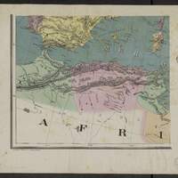
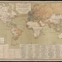
Europe. Carte murale à l'usage des écoles / E. Andriveau-Goujon ; gravé chez L. Wuhrer
Coordonnées géographiques converties du méridien de Paris au méridien de Greenwich -
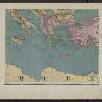
Europe. Carte murale à l'usage des écoles / E. Andriveau-Goujon ; gravé chez L. Wuhrer
Coordonnées géographiques converties du méridien de Paris au méridien de Greenwich -
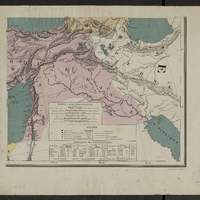
Europe. Carte murale à l'usage des écoles / E. Andriveau-Goujon ; gravé chez L. Wuhrer
Coordonnées géographiques converties du méridien de Paris au méridien de Greenwich -
Estancia Alvarez / Gran Estado Mayor 3a Division ; levantado por... Carmelo Suarez, Carlos Hasselbach, Juan B. Migliarini, Angel G. Falco
Coordonnées géographiques converties du méridien de Cordoba au méridien de Greenwich -
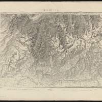
Topographische Karte der Schweiz. Blatt VII, Porrentruy-Solothurn
"Eidg. Topogr. Bureau 1887. Nachtrage 1899, 1901, 1902, 1905, 1906". Coordonnées géographiques converties du méridien de Paris au méridien de Greenwich. Relief représenté par des hachures et des points cotés -
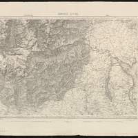
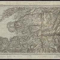
Topographische Karte der Schweiz. Blatt X, Feldkirch-Arlberg
"Ann. 1853. Nachtrage 1901, 1904, 1905, 1908". Coordonnées géographiques converties du méridien de Paris au méridien de Greenwich. Relief représenté par des hachures et des points cotés -
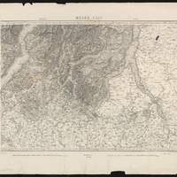
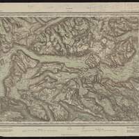
Topographische Karte der Schweiz. Blatt XVIII, Brig-Airolo
"Ann. 1854. Nachtrage 1904, 1905, 1907". Coordonnées géographiques converties du méridien de Paris au méridien de Greenwich. Relief représenté par des hachures et des points cotés -
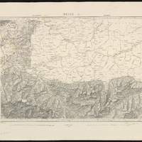
Topographische Karte der Schweiz. Blatt XIX, Bellinzona-Chiavenna
"Ann. 1858. Nachtrage 1901, 1907, 1908". Coordonnées géographiques converties du méridien de Paris au méridien de Greenwich. Relief représenté par des hachures et des points cotés -
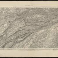
Topographische Karte der Schweiz. Blatt XXII, Martigny-Aoste
"Ann. 1861. Nachtrage 1904, 1908". Coordonnées géographiques converties du méridien de Paris au méridien de Greenwich. Relief représenté par des hachures et des points cotés -
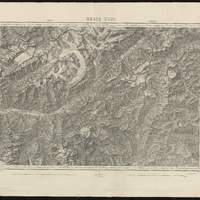
Topographische Karte der Schweiz. Blatt XXIII, Domo d'Ossola-Arona
"Ann. 1862. Nachtrage 1899, 1905, 1907". Coordonnées géographiques converties du méridien de Paris au méridien de Greenwich. Relief représenté par des hachures et des points cotés -
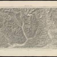
Topographische Karte der Schweiz. Blatt XXIV, Lugano-Como
"Ann. 1855. Nachtrage 1895, 1902, 1905, 1907". Coordonnées géographiques converties du méridien de Paris au méridien de Greenwich. Relief représenté par des hachures et des points cotés -
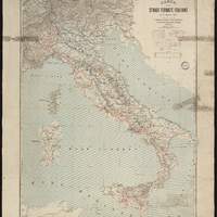
Carta delle strade ferrate italiane al 1o aprile 1891 / pubblicata per cura del R. Ispettorato Generale delle Strade Ferrate dall'Istituto cartografico italiano
Coordonnées géographiques converties du méridien de Rome au méridien de Greenwich -
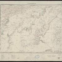
Topografisk kart over kongeriget Norge. 30 B, Bygdin
Equidistance des courbes : 30 m. Autre tirage : "Fjeldtonen litograferet af J. Nordhagen". Coordonnées géographiques calculées d'après le méridien de Christiana, Oslo -
Topografisk kart over kongeriget Norge. 47 C, Stjordalen
Coordonnées géographiques converties du méridien d'Oslo au méridien de Greenwich -
-
-
Manchester Ship Canal : General plan of canal and district, revised / published and issued by the authority of the Provisional Committee
[1:65 000 env.] (W 32' - W 210' / N 5334' - N 5315'). Textes en Anglais et en Français au verso: "The Manchester Ship Canal ; Documents publiés par la Commission organisatrice, Congrès de navigation intérieur a Bruxelles du 24 Mai au 2 Juin 1885. Coupe : "longitudinal section from Eastham to Manchester". Carton : "Enlarged plan of Manchester and Salford docks", au [1:7 920] (8 inches to 1 mile). Echelle calculée par comparaison avec une carte d échelle connue. Coordonnées géographiques d après Google Earth -
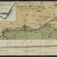
Album des services maritimes postaux français et étrangers Annexe 1, Carte générale des lignes télégraphiques internationales : avec notices commerciales sur les principaux ports français et étrangers : comprenant 8 grandes cartes, 24 pages de notices, un index et 2 grandes cartes annexes
En bas du document, 2 index : Pays pour lesquels il peut être envoyé des télégrammes et des taxe minima par mot. Principales communications télégraphiques terrestres et sous-marines du globe. -

-
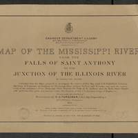
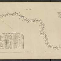
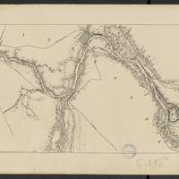
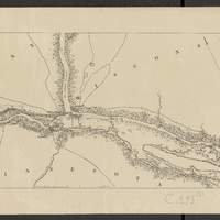
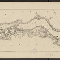
Map of the Mississippi River : from the Falls of Saint Anthony to the junction of the Illinois River in twenty-six sheets / drawn under the direction of Brevet Lieut. Col. F.U. Farquhar ; by F.S. Eastman
[1:63 360] (W 9316' - W 905' / N 45 - N 3850'). "Note : The position of the lights, as establlished in 1877 by the Light-House Board, are indicated on the map.". compiled from the maps prepared to accompany the reports of Bvt. Maj. Gen'l. G.K. Warren, U.S. Army Maj. Corps of Engineers, on bridging the Mississippi river between St. Paul and St. Louis ; and upon the improvement of navigation of the Mississippi River between the Falls of St. Anthony and the Rock Island Rapids, with additions from notes and surveys under the direction of Col. J.N. Macomb, Corps of Engineers. Comprends : 1 flle de titre ; 1 flle de tableau d'assemblage contenant un tableau des distances ; 26 flles de cartes numérotées de "sheet 1" à "sheet 26". Coordonnées géographiques d après Google Earth. Echelle d'après l'information : 1 inch to 1 mile -
Map of the Mississippi River : from the Falls of Saint Anthony to the junction of the Illinois River in twenty-six sheets / drawn under the direction of Brevet Lieut. Col. F.U. Farquhar ; by F.S. Eastman
[1:63 360] (W 9316' - W 905' / N 45 - N 3850'). "Note : The position of the lights, as establlished in 1877 by the Light-House Board, are indicated on the map.". compiled from the maps prepared to accompany the reports of Bvt. Maj. Gen'l. G.K. Warren, U.S. Army Maj. Corps of Engineers, on bridging the Mississippi river between St. Paul and St. Louis ; and upon the improvement of navigation of the Mississippi River between the Falls of St. Anthony and the Rock Island Rapids, with additions from notes and surveys under the direction of Col. J.N. Macomb, Corps of Engineers. Comprends : 1 flle de titre ; 1 flle de tableau d'assemblage contenant un tableau des distances ; 26 flles de cartes numérotées de "sheet 1" à "sheet 26". Coordonnées géographiques d après Google Earth. Echelle d'après l'information : 1 inch to 1 mile