
Recherche dans les données descriptives
550 items
-
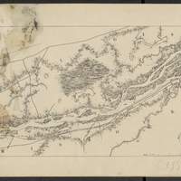
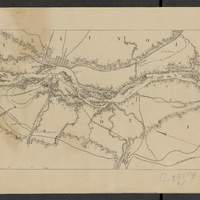
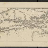
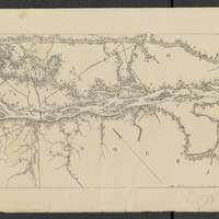
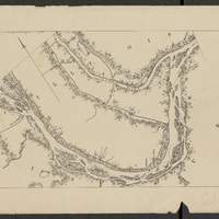
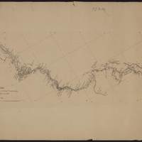
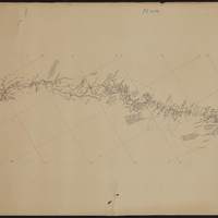
Map of the Mississippi River : from the Falls of Saint Anthony to the junction of the Illinois River in twenty-six sheets / drawn under the direction of Brevet Lieut. Col. F.U. Farquhar ; by F.S. Eastman
[1:63 360] (W 9316' - W 905' / N 45 - N 3850'). "Note : The position of the lights, as establlished in 1877 by the Light-House Board, are indicated on the map.". compiled from the maps prepared to accompany the reports of Bvt. Maj. Gen'l. G.K. Warren, U.S. Army Maj. Corps of Engineers, on bridging the Mississippi river between St. Paul and St. Louis ; and upon the improvement of navigation of the Mississippi River between the Falls of St. Anthony and the Rock Island Rapids, with additions from notes and surveys under the direction of Col. J.N. Macomb, Corps of Engineers. Comprends : 1 flle de titre ; 1 flle de tableau d'assemblage contenant un tableau des distances ; 26 flles de cartes numérotées de "sheet 1" à "sheet 26". Coordonnées géographiques d après Google Earth. Echelle d'après l'information : 1 inch to 1 mile -
Sénégal. Itinéraire de Médine à Makan 'Diambougou / Levé par Mr Vallières en 1880
Dédicace manuscrite : "Galliéni, chef de la mission, Mission du Haut-Niger 1880-1881". Coordonnées géographiques converties du méridien de Paris au méridien de Greenwich -
Sénégal. Itinéraire de Médine à Makan 'Diambougou / Levé par Mr Vallières en 1880
Dédicace manuscrite : "Galliéni, chef de la mission, Mission du Haut-Niger 1880-1881". Coordonnées géographiques converties du méridien de Paris au méridien de Greenwich -
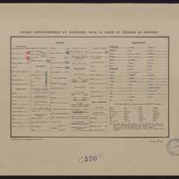
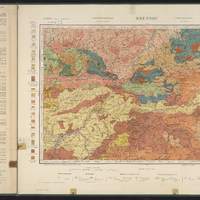
Signes conventionnels et écritures pour la carte du Sénégal au 100,000 e / publié par le Service Géographique de l'Armée
1:100 000. Légende concernant toutes les feuilles de la série Sénégal 100,000 e -
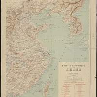
L'église catholique en Chine / dessiné et gravé par R. Hausermann
feuille "partie orientale" supplément au journal Les missions catholiques - 1912. Indique les vicariats et préfectures apostoliques en Chine. Supplément au journal : "Les Missions catholiques", 1913. feuille "partie occidentale" supplément au journal Les missions catholiques - 1913 -
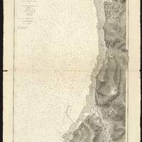
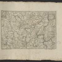
Plan du port de Boulogne et de ses environs
Dans la marge : "No. 3648". Bathymétrie représentée par des points de sonde (exprimées en m), relief représenté par des hachures. Edition d'origine : 1879. Coordonnées géographiques d'après Google Earth -
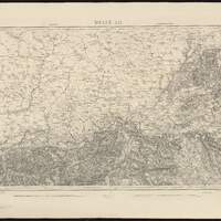
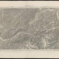
Topographische Karte der Schweiz. Blatt II, Belfort-Basel
"Ann. 1846. Nachtrage 1897, 1902, 1903, 1908". Coordonnées géographiques converties du méridien de Paris au méridien de Greenwich. Relief représenté par des hachures et des points cotés -
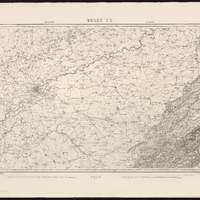
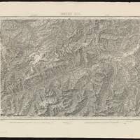
Topographische Karte der Schweiz. Blatt III, Liestal-Schaffhausen
"Ann. 1849. Nachtrage 1899, 1904, 1906". Coordonnées géographiques converties du méridien de Paris au méridien de Greenwich. Relief représenté par des hachures et des points cotés -
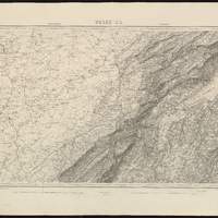
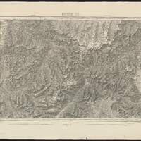
Topographische Karte der Schweiz. Blatt VI, Besançon-Le Locle
"Ann. 1846. Nachtrage 1902, 1905, 1907". Coordonnées géographiques converties du méridien de Paris au méridien de Greenwich. Relief représenté par des hachures et des points cotés -
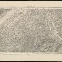
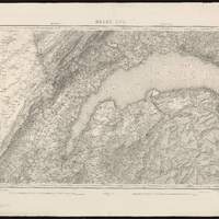
Topographische Karte der Schweiz. Blatt XI, Pontarlier-Yverdon
"Ann. 1849. Nachtrage 1898, 1902, 1903, 1905, 1907". Coordonnées géographiques converties du méridien de Paris au méridien de Greenwich. Relief représenté par des hachures et des points cotés -
Topographische Karte der Schweiz. Blatt XII, Freyburg-Bern
"Ann. 1860. Nachtrage 1899, 1900, 1902, 1903, 1905, 1906, 1907". Coordonnées géographiques converties du méridien de Paris au méridien de Greenwich. Relief représenté par des hachures et des points cotés -
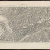
Topographische Karte der Schweiz. Blatt XIII, Interlaken-Sarnen-Stans
"Ann. 1864. Nachtrage 1895, 1900, 1901, 1905, 1907". Coordonnées géographiques converties du méridien de Paris au méridien de Greenwich. Relief représenté par des hachures et des points cotés -
Topographische Karte der Schweiz. Blatt XIV, Altdorf-Chur
"Ann. 1859. Nachtrage 1899, 1904, 1906, 1908". Coordonnées géographiques converties du méridien de Paris au méridien de Greenwich. Relief représenté par des hachures et des points cotés -
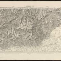
Topographische Karte der Schweiz. Blatt XV, Davos-Martinsbruck
"Ann. 1853. Nachtrage 1899, 1903, 1906, 1908". Coordonnées géographiques converties du méridien de Paris au méridien de Greenwich. Relief représenté par des hachures et des points cotés -
Topographische Karte der Schweiz. Blatt XVI, Genève-Lausanne
"Ann. 1842. Nachtrage 1898, 1900, 1903, 1905, 1907". Coordonnées géographiques converties du méridien de Paris au méridien de Greenwich. Relief représenté par des hachures et des points cotés -
Topographische Karte der Schweiz. Blatt XVII, Vevey-Sion
"Ann. 1844. Nachtrage 1903, 1905, 1906, 1908". Coordonnées géographiques converties du méridien de Paris au méridien de Greenwich. Relief représenté par des hachures et des points cotés -
Topographische Karte der Schweiz. Blatt XX, Sondrio-Bormio
"Ann. 1854. Nachtrage 1895, 1899, 1903, 1906, 1907, 1908". Coordonnées géographiques converties du méridien de Paris au méridien de Greenwich. Relief représenté par des hachures et des points cotés -
-
Théatre de la guerre actuelle, en Allemagne, en Pologne et en Turquie n°16, / P. G. Chanlaire
Indique les limites des départements de l'Empire en 1807