
Recherche dans les contenus numérisés
1887 items
-
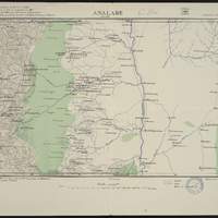
Carte de Madagascar au 1:100 000 Feuille 250, Analabe / dressé par le Capitaine Merienne-Lucas,... ; tiré au Service Géographique de l'Armée ; levers par R.P. Roblet, Capitaine Mounayres, Lieutenant Gaudaire et al. ; triangulation des R.P. Colin et Roblet
Coupure dérivée de la carte de Madagascar au 1:100 000. Sur la carte, les coordonnées sont indiquées en grades, sur la base du méridien de Paris. Les coordonnées ont été recalculées par rapport à Greenwich. Relief représenté par des courbes de niveau et des points cotés. L'équidistance des courbes est de 25 mètres -
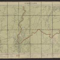
Carte de l'Indochine au 1:500 000 Feuille N°7, Vientiane / dressé, héliogravé et publié par le Service géographique de l'Indochine ; Le Lieut Colonel Dubuisson,...
Des noms des feuilles adjacentes sont indiquées sur les bords de la carte. Légende en français. Tableau d'assemblage dans la marge supérieure. Les coordonnées de la flle. sont au méridien de Paris (2 20' à l'est de Greenwich) et en grades (1 grade = 0.9 degré). Les coordonnées E/N indiquées sont au méridien de Greenwich. Quadrillage. Carte indique : les routes, chemins, fleuves, rivières, villes, villages, limites administratives -

Carte de l'Indochine au 1:100 000 Flle N° 244, Pointe de Ca-Mau / dressé, héliogravé et publié par le Service géographique de l'I̓ndochine
Légende en français. Carton : "Île Poulo Obi". Des noms des feuilles adjacentes sont indiquées sur les bords de la carte. Carte indique : les routes, chemins, forêts, fleuves, rivières, forêts, villes, villages, limites administratives. Tableau d'assemblage. Latitude et longitude sont exprimées en grades. Les coordonnées E/N indiquées sont au méridien de Greenwich. Quadrillage. Relief représenté par des courbes de niveau et des points cotés. L'équidistance des courbes est de 25 m -
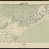
Carte de l'Indochine au 1:100 000 Flle N° 242, Bac-Lieu (carte provisoire) / dressé, héliogravé et publié par le Service géographique de l'Indochine
Légende en français. Des noms des feuilles adjacentes sont indiquées sur les bords de la carte. Carte indique : les routes, chemins, forêts, fleuves, rivières, forêts, villes, villages, limites administratives. Tableau d'assemblage. Latitude et longitude sont exprimées en grades. Les coordonnées E/N indiquées sont au méridien de Greenwich. Quadrillage. Relief représenté par des courbes de niveau et des points cotés. L'équidistance des courbes est de 25 m -
Carte des côtes méridionales de France. Partie comprise entre St. Tropez et la frontière
[1:153 000 env.] (E 630' -- E 737' / N 4355' -- N 4242'). Carte "No. 2682" et "9-28". Bathymétrie représentée par des points de sonde exprimés en mètres, relief représenté par des hachures. Révision en 1872. "Corrections essentielles en 1874, nov. 1880, janv. 1889". "Corrections secondaires en 1869, 1870, ... I-98". Coordonnées de longitude converties du méridien de Paris au méridien de Greenwich. Echelle calculée par comparaison avec une carte d échelle connue -
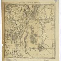
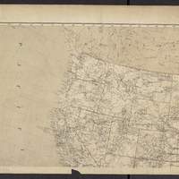
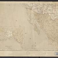
District of New Mexico / Lt. C.C. Morrison, 6th Cav. U.S.A., acting eng.r officer ; drawn by Anton Karl
"Headquarters Dept. of the Mo., Office of the Chief Engineer. Fort Leavenworth, Kas. Aug. 1845. Official copy William J. Volkurar 1st Level 5th Cav. in charge of office in abscence of Chief eng. Drawn by Anton Karl ; copied by G.A. Lichtenberg, Sergt. Engr.". Indique les forts de l'U.S. Army. Comprend liste des autorités : "Land office plats ; Boundary line surveys North East and South ; Maxwell Land Grant Survey ; Route of Capt. Macomb in 1857 ; Route of Capt. Simpson in 1849 ; Scouts in New Mexico since June 1872 ; Map of New Mexico by Lt. Ruffner ; Reconaissances by Lt. C.C. Morrison." -
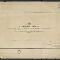
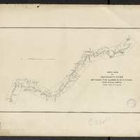
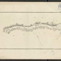
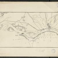
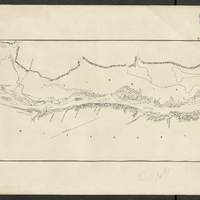
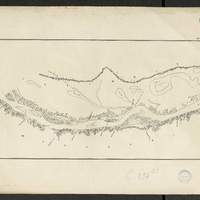
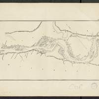
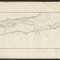
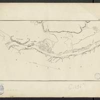
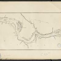
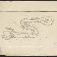
Map of the Mississippi River : between the mouth of the Illinois and the mouth of the Ohio Rivers / reduced from maps made from surveys under the direction of Lt. Col. W.F. Raynolds and Col. Jas. H. Simpson, Corps of Engineers, U.S.A., 1870-1878
[1:63 360] (W 9030' - W 896' / N 3859' - N 3657'). flles libres. Comprends : 1 flle de titre ; 1 flle index map, au 1:506 880 ; 9 flles de cartes numérotées de n1 à n9. Coordonnées géographiques d après Google Earth. Echelle d'après l'information : 1 inch to 1 mile -
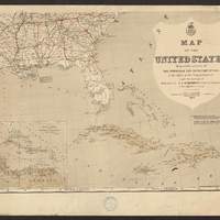
Map of the United States / prepared by authority of the Honorable the Secretary of War, in the Office of the Chief of Engineers, under the direction of Brig. General A.A. Humphreys, Chief of Engineers & Bvt. Maj. Gen'l, U.S. Army ; originally compiled and drawn by E. Freyhold
Sites militaires (arsenals, forts, etc.) indiqués par des drapeaux rouges. Cartons : "West Indies ans isthmus of Darien" au 1:20 000 000 ; "Territory of Alaska" au 1:20 000 000. Limites des états en rouge. Indique les réseaux de transport et les principales villes -
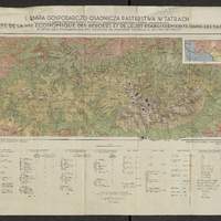
Mapa gospodarczo-osadnicza pasterstwa w Tatrach : i mapka etnograficzna z zasięgem wędrówek pasterskich i typów szałaśniczych = = Carte de la vie économique des bergers et leurs établissements dan les Tatra : et petite carte ethnographique avec l'extension des migrations pastorales et des types des chalets / opracowała Zofja Hołub-Pacewiczowa ; druk i oprac. kart. Wojsk. Instyt. Geograf. w Warszawie ; oprac. kart. por. Czarnota ; kreślił Wł. Oniszczyk
Légende structurée : I - terrains d'exploitation économique ; II A - types des chalets slovaques ; II B types des chalets de Jaworzyna -
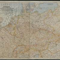
Germany and its approaches : with international boundaries as of September 1, 1939, the day Germany invaded Poland and, in red, boundaries as of January 1, 1938 before Germany seized Austria and Czechoslovakia / compiled and drawn in the Cartographic Section of the National Geographic Society for the National Geographic magazine / James M. Darley, chief cartographer ; Gilbert Grosvenor, editor
Carte de l'Allemagne et des pays voisins, montre les routes, les chemins de fer, canaux, tunnels, villes, régions, hydrographie et frontières d'états en 1938/1939 -
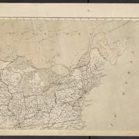
Map of the Yellowstone and Missouri Rivers : and their tributaries / explored by Capt. W. F. Raynolds, Topl. Engrs., and 1st Lieut. H. E. Maynadier, 10th Infy. Assistant, 1859-60 ; revised and enlarged by Major G. L. Gillespie, U.S. Engr's., Bvt. Lt. Col., U.S.A. Chief Engr. Military Division of the Missouri, 1876 ; published by authority of the Hon. the Secretary of War, Office of the Chief of Engineers, U.S. Army, 1876
En bas à gauche : "Western sheet. Map of Yellowstone and Missouri Rivers. From Capt. Raynolds exploration 1859-60, with additions by Major Gillespie. Published by authority of the Hon. the Secretary of War, Office of the Chief of Engineers, U.S. Army. 1877." -
Map of the Yellowstone and Missouri Rivers : and their tributaries / explored by Capt. W. F. Raynolds, Topl. Engrs., and 1st Lieut. H. E. Maynadier, 10th Infy. Assistant, 1859-60 ; revised and enlarged by Major G. L. Gillespie, U.S. Engr's., Bvt. Lt. Col., U.S.A. Chief Engr. Military Division of the Missouri, 1876 ; published by authority of the Hon. the Secretary of War, Office of the Chief of Engineers, U.S. Army, 1876
En bas à gauche : "Western sheet. Map of Yellowstone and Missouri Rivers. From Capt. Raynolds exploration 1859-60, with additions by Major Gillespie. Published by authority of the Hon. the Secretary of War, Office of the Chief of Engineers, U.S. Army. 1877."