
Recherche dans les contenus numérisés
2144 items
-
Guinée portugaise et possessions françaises voisines / Cap[itai]ne Brosselard, L[ieutenan]t Clerc, M[onsieu]r Galibert ; gravé par J. Geisendörfer
Carton de situation. "D'après la carte dressée par la Commission française de délimitation". Sur la carte, la longitude est indiquée sur la base du méridien de Paris. Les coordonnées ont été recalculées par rapport à Greenwich -
Carte de Madagascar au 1:500 000 ème Feuille n°14, Tananarive / dressée au Service géographique du Corps d'Occupation (septembre 1903) ; dessinée par P. Cabanes, figuré du terrain exécuté par Gros ; gravure par Samuel Rahamefy et Pierre Andrianary
Autre édition sur le même support Carte de Madagascar au 1:500 000 ème. Autre édition sur le même support Carte de Madagascar au 1:500 000 ème -
Carte de Madagascar au 1:500 000 ème Feuille n°22, Tuléar / dressée au Service géographique du Corps d'occupation (octobre 1903) ; dessiné par P. Cabanes, figuré du terrain exécuté par Ch. Gros ; gravure par S. Razafindrazaka et P. Andrianary
Autre édition sur le même support Carte de Madagascar au 1:500 000 ème. Autre édition sur le même support Carte de Madagascar au 1:500 000 -
Carte de Madagascar au 1:500 000 Feuille n°4, quart sud-est, Soavinandriana / dressé par le Capitaine Merienne Lucas,... ; dessiné par le Sergent Gros ; gravé par le Caporal J. Bach ; tiré au Service géographique du Corps d'occupation (novembre 1898)
Montre : les villes, villages, cours d'eau, végétation, routes. Sur la carte, les coordonnées sont indiquées en grades, sur la base du méridien de Paris. Les coordonnées ont été recalculées par rapport à Greenwich. Relief représenté par estompage -
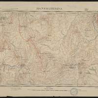
Carte de Madagascar au 1:100 000 Feuille 208, Manerinerina / dressé et tiré au Service Géographique du Corps d'Occupation en 1899 ; Levers par les Capitaines Mauriès, Steiner et le Caporal Mangin ; Triangulation du R.P. Colin
La 2e carte constitue un complément à l'ouest de la première. Montre : les villes, villages, routes, sentiers, fleuves, cours d'eau, la végétation.... Sur la carte, les coordonnées sont indiquées en grades, sur la base du méridien de Paris. Les coordonnées ont été recalculées par rapport à Greenwich -
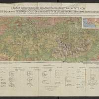
Mapa gospodarczo-osadnicza pasterstwa w Tatrach : i mapka etnograficzna z zasięgem wędrówek pasterskich i typów szałaśniczych = = Carte de la vie économique des bergers et leurs établissements dan les Tatra : et petite carte ethnographique avec l'extension des migrations pastorales et des types des chalets / opracowała Zofja Hołub-Pacewiczowa ; druk i oprac. kart. Wojsk. Instyt. Geograf. w Warszawie ; oprac. kart. por. Czarnota ; kreślił Wł. Oniszczyk
Légende structurée : I - terrains d'exploitation économique ; II A - types des chalets slovaques ; II B types des chalets de Jaworzyna -
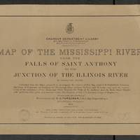
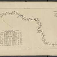
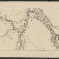
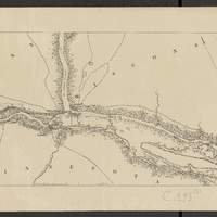
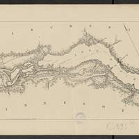
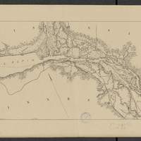
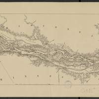
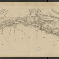
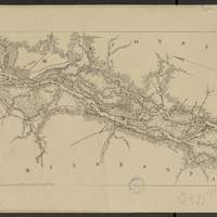
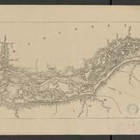
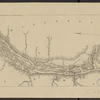
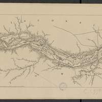
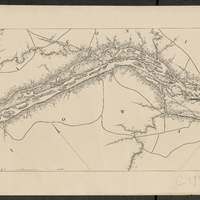
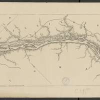
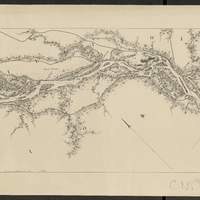
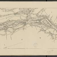
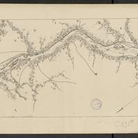
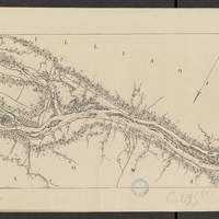
Map of the Mississippi River : from the Falls of Saint Anthony to the junction of the Illinois River in twenty-six sheets / drawn under the direction of Brevet Lieut. Col. F.U. Farquhar ; by F.S. Eastman
[1:63 360] (W 9316' - W 905' / N 45 - N 3850'). "Note : The position of the lights, as establlished in 1877 by the Light-House Board, are indicated on the map.". compiled from the maps prepared to accompany the reports of Bvt. Maj. Gen'l. G.K. Warren, U.S. Army Maj. Corps of Engineers, on bridging the Mississippi river between St. Paul and St. Louis ; and upon the improvement of navigation of the Mississippi River between the Falls of St. Anthony and the Rock Island Rapids, with additions from notes and surveys under the direction of Col. J.N. Macomb, Corps of Engineers. Comprends : 1 flle de titre ; 1 flle de tableau d'assemblage contenant un tableau des distances ; 26 flles de cartes numérotées de "sheet 1" à "sheet 26". Coordonnées géographiques d après Google Earth. Echelle d'après l'information : 1 inch to 1 mile -
Map of the Mississippi River : from the Falls of Saint Anthony to the junction of the Illinois River in twenty-six sheets / drawn under the direction of Brevet Lieut. Col. F.U. Farquhar ; by F.S. Eastman
[1:63 360] (W 9316' - W 905' / N 45 - N 3850'). "Note : The position of the lights, as establlished in 1877 by the Light-House Board, are indicated on the map.". compiled from the maps prepared to accompany the reports of Bvt. Maj. Gen'l. G.K. Warren, U.S. Army Maj. Corps of Engineers, on bridging the Mississippi river between St. Paul and St. Louis ; and upon the improvement of navigation of the Mississippi River between the Falls of St. Anthony and the Rock Island Rapids, with additions from notes and surveys under the direction of Col. J.N. Macomb, Corps of Engineers. Comprends : 1 flle de titre ; 1 flle de tableau d'assemblage contenant un tableau des distances ; 26 flles de cartes numérotées de "sheet 1" à "sheet 26". Coordonnées géographiques d après Google Earth. Echelle d'après l'information : 1 inch to 1 mile